Friday, February 19, 2016

Puerto Rico and Vieques


Old San Juan

In early February, we left Providence RI on American Airlines early in the morning, and after a stop in Charlotte S.C. we landed mid- afternoon in San Juan, Puerto Rico. A taxi into Old San Juan from the airport cost $24.00 and delivered us to the Gallery Inn on Norzagaray St. The Inn is a fascinating place, owned by artist Jan D'Esopo, who has lived in San Juan for years but is originally from CT.

Parrot at the Inn
Her sculptures and her sister's paintings are everywhere throughout the inn. The Inn is a work of art itself, with all kinds of nooks and crannies to explore. There are parrots and orchids and you might find Ms. D'Esopo's sister painting portraits in one of the galleries. You can commission her to do a portrait if the mood strikes. Be aware, though, this is a 300 year old place. It has lots of atmosphere and a great location, but not necessarily a great hot shower in the morning. Things like modern plumbing have to be cobbled together in a place like this.The floors and walls are old, so if you like being in a place that's sparkling new, this isn't for you.

At the Gallery Inn
Old San Juan is beautiful, full of pastel colored buildings and flowers. There are two Spanish fortresses within walking distance of the inn where we stayed, part of the San Juan National Historic Site. $5.00 buys you entrance to both. The views are amazing and there's usually a breeze, so on a sunny day they are fantastic places to explore.

OSJ restaurants
Spanish fortresses
You'll have fun just walking around OSJ. There are a lot of restaurants and bars. In general, you don't want to have a car here, the streets are very narrow and parking is difficult.

We rented a car one day and drove to El Yunque National Forest, the only tropical rainforest in the national forest system. GPS is a good thing to have, as we almost missed the turn off the main road to the forest. It's not as well marked as you might think. Many of the trails seemed to be closed, but we did hike to La Mina Falls in the rain. Going down is easy, coming back up a little tougher. We had umbrellas, but you might want to just wear your bathing suit. You can get in the water at the Falls and change into dry clothes back at your car.

El Yunque Rainforest
We met friends in Condado and hired a van to take us to Fajardo, where we took an hour-long ferry to the island of Vieques. As senior citizens, the ferry cost only $1.00 each way! We rented a house for the week in the town of Isabel Segunda, a charming place with narrow streets where horses and chickens wander freely.

It's a great place to vacation. There are a lot of beautiful beaches. You'll have to rent a Jeep to get to most of them, as the roads are often rough. Playa Media Luna was probably our favorite. It's a protected cove so the water was calm and easy to get in and out of. It was also easy to find shade to sit in.
View from the deck, Isabel Segunda


If you're going to Vieques, you absolutely have to go to the Bioluminous Bay. This is best seen during a new moon, which also makes it better to see the thousands of stars in the Milky Way right overhead. Microscopic plankton in the water glow like fireflies when they are disturbed or come into contact with another organism.

Also, don't miss the little town of Esperanza, a beachside town with a number of restaurants and shops right across the street. We ate at the restaurant Bananas, once for lunch and once upstairs for dinner.

Esperanza


Upstairs at Bananas


Tuesday, September 2, 2014

Seattle and Olympic National Park

Seattle


Fast elevator: the trip up takes about 45 seconds.
Turns out, it does not rain continuously in Northwest Washington state! We had eight sunny days at the end of August.

The Space Needle, built as the centerpiece for the 1962 World's Fair, is a must-see. The day we visited was crystal clear and the view from atop the 605 foot structure was spectacular, although Mount Rainier was not visible. Luckily, no swaying as it did during the Great Alaska Earthquake of 1964.
Great view


Great tour guide


We took an interesting tour of Seattle's Underground. We explored old sidewalks one story below the current ones. To make a long story short, Seattle's "ground" level was raised one story after a major fire in 1889. This was done to prevent flooding and sewer backups during high tide. Walking in this underworld, you can see the original first floor (now the basement) of several buildings and look up through skylights in the current sidewalks made of small pieces of glass.


Selecting


Performing
Deciding

It seems everyone visits the Pike Place Market. Even if you buy nothing, and it is nearly impossible not to, the people watching is outstanding.


The Japanese Garden


Washington Park provides access to Lake Washington and hosts a beautiful arboretum maintained by the University of Washington.
A friendly place


We spent an enjoyable hour or two at this old saloon at Pioneer Square on our last evening in town. Great bartenders. Also on our last night, we stayed at a hotel near Sea-Tac Airport, which is a distance from downtown Seattle.  We took the light rail from the airport to Chinatown.


That was a big tree
Olympic National Park


The temperate rain forest was a "bucket list" item, and it was nice to visit it on a sunny day! Unlike tropical rain forests, which consist mostly of deciduous trees, this forest is primarily coniferous: Sitka spruce, Douglas fir, western hemlock. A few glorious big leaf maples can also be found.


Almost tame


Why is there a rain forest? Because the mountains on the Olympic peninsula block the cold Canadian air sweeping down in the winter. Warm wet air comes up the coast from California.

We met this black-tailed deer on a spectacular hike at Hurricane Ridge.  Our presence was only a minor annoyance to him.


Mount Olympus, 7980 feet
Sea stacks, fog, and gray sand at La Push on the Pacific coast.


Hurricane Ridge was also our vantage point for viewing the several active glaciers near the summit of Mount Olympus. (Zeus does not reside here.)


A separate section of the National Park along the Pacific coast provides a mystical scene and cool temperatures. Signs warn of Tsunami danger.


Port Angeles and Port Townsend


View of Port Angeles

To visit the park, we stayed at the Quality Inn in Port Angeles, which is on top of a bluff giving a great view of downtown, the Strait of Juan de Fuca and Canada beyond. A staircase connects top and bottom right outside the hotel, which was convenient.

Lumber is king here. There is a constant stream of logging trucks in and out of town. There is also a ferry to the city of Victoria, Canada, just across the Strait, that leaves several times a day.


The Lake Crescent Lodge

We went swimming one day at Lake Crescent, an absolutely beautiful lake in the park, and had lunch at the Lake Crescent Lodge.


Port Townsend was our last port of call. It's a charming city with a lot of Victorian architecture. It's more upscale than Port Angeles, with a lot of shopping and restaurants on the waterfront. And be sure to visit Fort Worden Park, with its beach and lighthouse.


Port Townsend


Sunday, February 2, 2014

Las Vegas and Death Valley

We left Rhode Island on Southwest Air, an early morning flight to Chicago then on to Las Vegas. Both flights were packed, but arrived on time and with luggage.

The Las Vegas airport is not an experience to recommend. A walk plus tram ride to baggage claim, a huge place with hundreds of people trying to get their luggage. Then line up for a bus ride to the car rental building, line up again to see the person at the counter, who tries to get you to upgrade (no thanks) and tries to scare you into buying more insurance (again, no thanks).

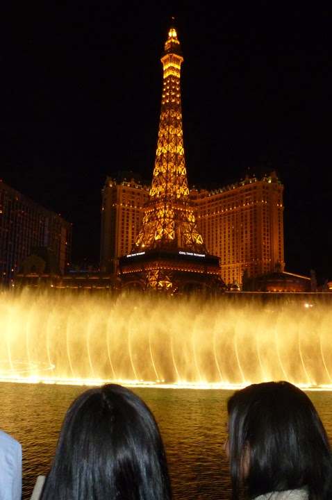
View from the Bellagio Casino
Finally, in the car and riding down the Strip. It is Disney for adults- Egyptian pyramids, the Statue of Liberty and the Brooklyn Bridge, the Eiffel Tower and Arc de Triomphe, Rome, Venice complete with gondolas- it's crazy. We're staying at the Flamingo, right in the middle of the action. After parking in their garage, we check in. They want $30. for early check-in but will waive it if I get a rewards card, so I do. A good room on the 10th floor, facing the Strip, but don't expect little niceties like a coffeemaker. If you want to eat or drink, go downstairs to one of the many restaurants and bars.
We go out for a walk and food. Las Vegas has gotten huge since we were there last, nearly 20 years ago. Much more traffic, more people, crowds on the street like New York. We get a bite to eat and a beer at a sidewalk place and watch 2 gorgeous blonde girls who are dressed like cops, except with bikinis and platform boots along with the handcuffs, nightsticks and leather jackets. Everyone- well, every guy- wants to have their picture taken with them, and they're pulling in money like crazy. The waiter says they're there every day, so they must be doing pretty well.

In Las Vegas, you always feel like you're being hustled.  FYI- those "free" tickets to shows may well have one-drink minimums, and the half price "Tix4tonight" may be for general admission, not reserved seats, which could mean more standing in line.

Las Vegas is surrounded by mountains and has some fantastic scenery. The next day we head out to Red Rock Canyon National Conservation Area, which I highly recommend. You can just ride the 13 mile loop road, or stop and do some hikes.
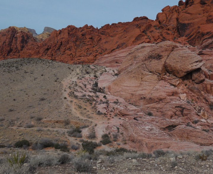
Red Rock Canyon
We also visit Valley of Fire State Park, which I also recommend, about an hour's drive west of the city. On our way back to Las Vegas we drive through the Lake Mead National Recreation Area. Breathtaking, constantly changing desert scenery.

Hiking at Valley of Fire


We head out to Beatty, NV on the fourth day, where we're staying to visit Death Valley National Park.  The weather is great, in the 50's and 60's, sometimes sunny and sometimes overcast. Much better than New England in January. On our way there we stop at Ash Meadows National Wildlife Refuge. It's pretty amazing to see springs of water in the desert, and even more amazing to read about how the whole place almost became a housing development/ casino/golf course.
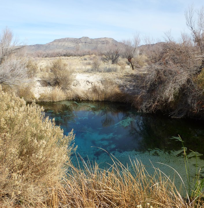
Crystal Spring at Ash Meadows


 We're staying at the Exchange Club Motel in Beatty, right on Main St. Across the street are the Sourdough Saloon, the Happy Burro, and KC's Outpost, all of which we patronize during our stay. The menus are limited but the people are very friendly.

After settling in, we drive 4 miles down the road to Rhyolite, a ghost town with an interesting story behind it. Lots of picture taking going on here!
Rhyolite

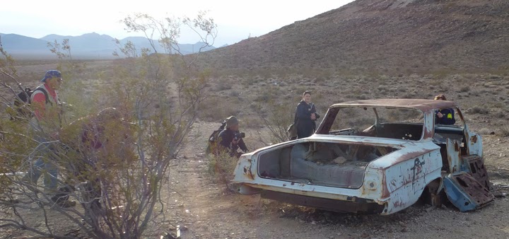
Photographers in Rhyolite
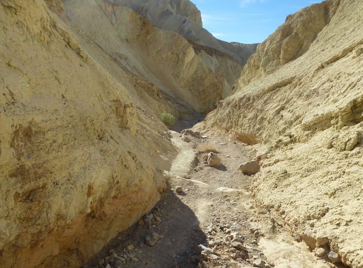
The next day, Death Valley. We go to Furnace Creek, stop and hike up Golden Canyon, go to Badwater, and then do the Artists Palette Drive on the way back. Then on to Zabriskie Point and Dante's View, an amazing place to see a bird's eye view of the Valley. We tried to see the Natural Bridge, but the road was rough and we got nervous with our rental car, so we turned around. The park is young and  a number of roads are still unpaved.
Golden Canyon


Dante's View

We were told, one night at the Sourdough Saloon, that Titus Canyon is a must see. The turnoff is a few miles west of  Beatty, a one way road through the canyon that ends on Scotty's Castle Rd. Four wheel drive is recommended, and a local bartender told us that getting towed out of there will set you back $2000. Sadly, we decided to skip it, although there are jeep tours if you have the time.
From Death Valley we went to visit friends, then there was a long drive back to Las Vegas to fly home.

Tuesday, August 20, 2013

Along U.S. Route 6

U.S. Route 6 runs from Bishop, California to Provincetown, Massachusetts, a distance of 3205 miles through 14 states. It is officially called the Grand Army of the Republic or the G.A.R. Highway. It used to go all the way to the pacific coast at Long Beach, but a section was decommissioned in 1964. Prior to this decommissioning, it was the longest transcontinental route, spanning 3652 miles. That title is now held by U.S. Route 20.
Route 6 has been a thread throughout our adult lives. Except in our childhoods, we've almost always lived along it: in Mattapoisett, Fairhaven, New Bedford, and North Dartmouth, Massachusetts and now in East Providence, Rhode Island. It has popped up on several western trips. We noticed it in Denver and, during a trip to Kings Canyon and Sequoia National Parks, we saw its western end. See the sign at the California end.

The east end of U.S. Route 6 is marked with this sign, which needs to be revised.


Cape Cod National Seashore

Three short hikes (totaling about two miles) in Provincetown and Truro show glacial effects and feature miniature forests of low growing trees. These tiny forests surround small fresh water ponds and provide oases in the sand dunes. Mainly evident are pitch pine, beech, tupelo, and black and white oak. It's amazing that trees can grow at all in such a sandy soil. Recommended hikes are Beech Forest in Provincetown and, at Pilgrim Heights in Truro, Small's Swamp Trail and Pilgrim Spring Trail. Beech Forest is located in Provincelands which also features a seven mile bike trail.

Beech Forest trail


Freshwater oasis in the dunes

Meadow by the sea


Connecticut/Rhode Island Border

When it crosses from Rhode Island into Connecticut, Route 6 runs right past Old Furnace State Park in Killingly. This small gem features beautiful and interesting terrain. The woodland showcases large white pines, pitch pine, oak, maple, hickory and birch but, unfortunately, the hemlocks are dying because of infestation by a non-native insect, the hemlock woolly adelgid. Rocky outcrops and glacial erratics are evident all along a three mile trail. The highlight of the walk is the view from a 200 foot cliff over Half Hill Pond looking east into Rhode Island. The cliff is used by technical rock climbers.

Dead and dying hemlocks
Rock climbers below!
The view from the cliff
Glacial landscape
Post by Paul Courcy

Friday, September 7, 2012

Old Growth Forests and 1/1000th of the Appalachian Trail

This posting combines two summer 2012 forays in search of old growth forest in the northeast. Almost all the original forest encountered by European settlers was cleared for farms, and the rest was logged for timber by the 1920s. Only small patches remain, escaping the lumberman's saw and axe because of inaccessibility, steep slopes, or boundary issues. Featured here are two sites in Pennsylvania and one in Connecticut.

Pennsylvania

Hearts Content Scenic Area in western PA is a long way to travel for a one-mile loop hike, but if you're a tree lover, it's worth the trip. The girth of some of the oldest trees could challenge any tree hugger. The oldest eastern white pines are approximately 400 years old. Other large specimens include eastern hemlock and American beech, although the latter are being killed by beech bark disease.

Looking up at the canopy
A towering hemlock

In Cook Forest State Park, one can still see dead trunks of the American chestnut, which succumbed to chestnut blight, accidentally imported from China or Japan around 1900. The park, once called the "Black Forest", contains a "Forest Cathedral" of towering eastern white pines and eastern hemlocks and is designated a National Natural Landmark. The "swamp area" contains red and white oaks, red maples, and black cherry, some over 280 years old. If you visit, be sure to hike the 1.2 mile Longfellow Trail which passes through many 300 to 400 year old trees. Many of the white pines reach 150 feet in height.

The Eastern white pines are the tallest, up to 183 feet...

...but hemlock are the most abundant of the giants

Very tall oaks and maples are a pain in the neck


 The twisted "snag" of a chestnut tree, which probably died in the 1920s


Connecticut

When thinking about the 2,184-mile Appalachian Trail, the state of Connecticut does not come readily to mind. Far more dramatic views from the famous trail can be found in North Carolina's Great Smoky Mountains or in New Hampshire's Presidential Range. But traveling on lesser known sections offers more subtle (and less strenuous) beauty. Hiking a 2.1 mile section in the northwest corner of Connecticut took me over Bear Mountain, the highest summit in that state (although the highest point in the state is about a mile west on the south slope of Mt. Frissell whose summit is in Massachusetts), and through a picturesque gorge known as Sage's Ravine. The forest here is technically "second-growth" or regrown forest, but it looks very similar to true old growth. The best way to access this section of the Appalachian Trail is through Mount Washington State Forest at the southwest corner of Massachusetts.

The view from Bear Mountain
Sage's Ravine


Some other old growth forests in eastern US:
Mount Greylock, MA
Landis Arboretum, NY
Linville Gorge Wilderness,  NC
Joyce Kilmer-Slickrock Wilderness, NC
Joyce Kilmer Memorial Forest, NC

A list of old growth forests

Post by Paul Courcy